Click here to register!
Difference between revisions of "Afghanistan Energy Situation"
***** (***** | *****) m |
***** (***** | *****) m |
||
| Line 1: | Line 1: | ||
| − | {| | + | |
| + | {| cellspacing="0" cellpadding="0" border="1" style="width: 400px; float: right" | ||
|- | |- | ||
| − | | | + | | style="text-align: center" colspan="4" | '''Afghanistan'''<br/> |
|- | |- | ||
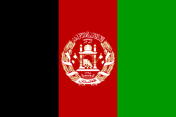
| − | | | + | | [[File:Flag of Afghanistan.svg|border|center|File:Flag of Afghanistan.svg|alt=File:Flag of Afghanistan.svg]]<br/> |
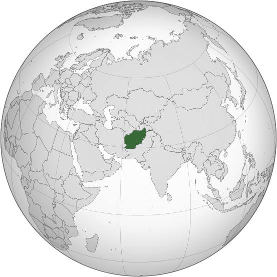
| − | | | + | | [[File:Afghanistan (orthographic projection).svg|border|center|File:Afghanistan (orthographic projection).svg|alt=File:Afghanistan (orthographic projection).svg]]<br/> |
|- | |- | ||
| | | | ||
| Line 10: | Line 11: | ||
| | | | ||
| − | + | Kabul ([http://toolserver.org/~geohack/geohack.php?pagename=Kabul&language=de¶ms=34.533333333333_N_69.166666666667_E_dim:20000_region:AF-KAB_type:adm1st(3043589)&title=Kabul 34° 32′ 0″ N, 69° 10′ 0″ E]) | |
|- | |- | ||
| Line 17: | Line 18: | ||
| | | | ||
| − | + | Dari (Persian) and Pashto | |
|- | |- | ||
| Line 24: | Line 25: | ||
| | | | ||
| − | + | Islamic republic | |
|- | |- | ||
| Line 31: | Line 32: | ||
| | | | ||
| − | + | Hamid Karzai | |
|- | |- | ||
| Line 38: | Line 39: | ||
| | | | ||
| − | + | ||
|- | |- | ||
| Line 45: | Line 46: | ||
| | | | ||
| − | + | 647,500 km<sup>2</sup> | |
|- | |- | ||
| Line 52: | Line 53: | ||
| | | | ||
| − | + | 29.8 million | |
|- | |- | ||
| Line 59: | Line 60: | ||
| | | | ||
| − | + | 23 million (77%) | |
|- | |- | ||
| Line 66: | Line 67: | ||
| | | | ||
| − | + | 6.8 million (23%) | |
|- | |- | ||
| Line 73: | Line 74: | ||
| | | | ||
| − | + | 43 Persons per km² | |
|- | |- | ||
| Line 80: | Line 81: | ||
| | | | ||
| − | + | 11.4 | |
|- | |- | ||
| Line 87: | Line 88: | ||
| | | | ||
| − | + | $15.608 billion | |
|- | |- | ||
| Line 94: | Line 95: | ||
| | | | ||
| − | + | $517 | |
|- | |- | ||
| Line 101: | Line 102: | ||
| | | | ||
| − | + | Afghani (AFN) | |
|- | |- | ||
| Line 108: | Line 109: | ||
| | | | ||
| − | + | CET (UTC+04:30) | |
|- | |- | ||
| Line 115: | Line 116: | ||
| | | | ||
| − | + | +93 | |
|} | |} | ||
| − | {| | + | {| cellspacing="1" cellpadding="1" border="0" align="left" style="width: 350px" class="FCK__ShowTableBorders" |
|- | |- | ||
| __TOC__ | | __TOC__ | ||
| Line 125: | Line 126: | ||
|} | |} | ||
<div style="clear: both"></div> | <div style="clear: both"></div> | ||
| − | == | + | = Overview = |
| − | |||
| − | |||
| − | |||
| − | |||
| − | |||
| − | |||
| − | |||
| − | |||
| + | = Geography and Climatic Conditions<br/> = | ||
| + | *Arid to semiarid; cold winters and hot summers | ||
| + | *Mean temperature (°C min/max): 4.3/19.6 <ref name="UN Data">UN Data (2008): http://data.un.org/CountryProfile.aspx?crName=Afghanistan</ref> | ||
| + | *Natural gas, petroleum, coal <ref name="null">CIA - The World Factbook: https://www.cia.gov/library/publications/the-world-factbook/geos/af.html</ref> | ||
| + | *Land area covered by forest: 1.3% | ||
| + | *Forest annual rate of change: 0% <ref>FAO (2011) The State of the World's Forest</ref> | ||
| − | + | <br/> | |
| + | = Socioeconomical Situation<br/> = | ||
| + | == Income Sources == | ||
| − | + | *Agriculture: 79% | |
| − | + | *Industry: 6% | |
| − | |||
| − | |||
| − | |||
| − | |||
| − | *Agriculture: 79% | ||
| − | *Industry: 6% | ||
*Services: 16% | *Services: 16% | ||
| − | + | <br/> | |
= National Energy Situation = | = National Energy Situation = | ||
| − | |||
| − | |||
| − | |||
| − | |||
== Energy Supply<br/> == | == Energy Supply<br/> == | ||
| − | |||
| − | |||
=== Electricity === | === Electricity === | ||
| Line 167: | Line 156: | ||
==== Sources ==== | ==== Sources ==== | ||
| − | Hydropower 63,7% | + | *Hydropower 63,7% |
| + | *fossil fuels 35,3% | ||
| − | |||
| + | ==== Stability ==== | ||
== Energy Consumption == | == Energy Consumption == | ||
| − | |||
| − | |||
| Line 191: | Line 179: | ||
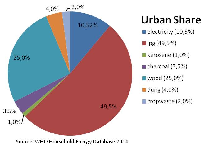
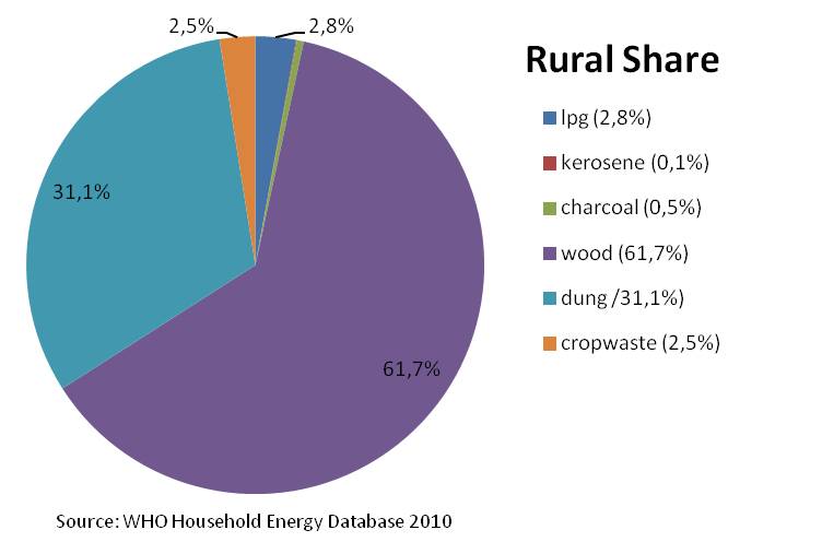
Percentage of energy types used for cooking in rural areas <ref name="WHO 2010">WHO 2010: WHO Household Energy Database</ref> | Percentage of energy types used for cooking in rural areas <ref name="WHO 2010">WHO 2010: WHO Household Energy Database</ref> | ||
| − | <br/> | + | <br/> |
| − | [[File:Afghanistan Urban Share.jpg| | + | [[File:Afghanistan Urban Share.jpg|Afghanistan Urban Share.jpg|alt=Afghanistan Urban Share.jpg]]<br/>Percentage of energy types used for cooking in rural areas. <ref name="WHO 2010">WHO 2010: WHO Household Energy Database</ref><br/> |
| − | <br/>[[File:Afghanistan Rural Share.jpg| | + | <br/>[[File:Afghanistan Rural Share.jpg|Afghanistan Rural Share.jpg|alt=Afghanistan Rural Share.jpg]] |
| − | |||
| − | |||
| − | ==== Percentage of Population Using Solid Fuels | + | |
| + | |||
| + | ==== Percentage of Population Using Solid Fuels ==== | ||
National: >95% <ref>WHO (2006): Fuels for Life</ref> | National: >95% <ref>WHO (2006): Fuels for Life</ref> | ||
| + | <br/> | ||
| − | + | ==== Solid Fuel Use Impact on Health ==== | |
| − | ==== Solid Fuel Use Impact on Health | ||
Total annual deaths attributable to solid fuel use: 23900 persons<br/>Percentage of national burden of diseases attributable to solid fuel use: 4.9% <ref>WHO (2006): Fuels for Life</ref> | Total annual deaths attributable to solid fuel use: 23900 persons<br/>Percentage of national burden of diseases attributable to solid fuel use: 4.9% <ref>WHO (2006): Fuels for Life</ref> | ||
| − | + | <br/> | |
== Access Rate == | == Access Rate == | ||
| − | === Electrification Rate | + | === Electrification Rate === |
Electrification rate in households:<ref>The National Risk and Vulnerability Assessment 2005, Kabul, Afghanistan. Cited in WHO (2009) The Energy Access Situation in developing Countries</ref> | Electrification rate in households:<ref>The National Risk and Vulnerability Assessment 2005, Kabul, Afghanistan. Cited in WHO (2009) The Energy Access Situation in developing Countries</ref> | ||
| − | |||
*National: 23% | *National: 23% | ||
*Urban: 74% | *Urban: 74% | ||
*Rural: 3% | *Rural: 3% | ||
| − | + | <br/> | |
= Policy Framework, Laws and Regulations<br/> = | = Policy Framework, Laws and Regulations<br/> = | ||
| − | = Relevant Institutions | + | = Relevant Institutions and Organisations <br/> = |
= Existing Projects<br/> = | = Existing Projects<br/> = | ||
| − | |||
| − | |||
= References = | = References = | ||
| − | + | <references /> | |
| − | |||
[[Category:Afghanistan]] | [[Category:Afghanistan]] | ||
Revision as of 08:17, 18 June 2013
| Afghanistan | |||
|
Capital |
Kabul (34° 32′ 0″ N, 69° 10′ 0″ E) | ||
|
Official language(s) |
Dari (Persian) and Pashto | ||
|
Government |
Islamic republic | ||
|
President |
Hamid Karzai | ||
|
Prime Minister |
| ||
|
Total area |
647,500 km2 | ||
|
Population [1] |
29.8 million | ||
|
Rural-Population |
23 million (77%) | ||
|
Urban-Population |
6.8 million (23%) | ||
|
Population Density |
43 Persons per km² | ||
|
Average Household Size |
11.4 | ||
|
GDP (nominal) |
$15.608 billion | ||
|
GDP per Capita |
$517 | ||
|
Currency |
Afghani (AFN) | ||
|
Time Zone |
CET (UTC+04:30) | ||
|
Calling Code |
+93 | ||
Overview
Geography and Climatic Conditions
- Arid to semiarid; cold winters and hot summers
- Mean temperature (°C min/max): 4.3/19.6 [2]
- Natural gas, petroleum, coal [1]
- Land area covered by forest: 1.3%
- Forest annual rate of change: 0% [3]
Socioeconomical Situation
Income Sources
- Agriculture: 79%
- Industry: 6%
- Services: 16%
National Energy Situation
Energy Supply
Electricity
Sources
- Hydropower 63,7%
- fossil fuels 35,3%
Stability
Energy Consumption
National Level
Electricity
Household Level
Percentage of energy types used for cooking in rural areas [4]

Percentage of energy types used for cooking in rural areas. [4]
Percentage of Population Using Solid Fuels
National: >95% [5]
Solid Fuel Use Impact on Health
Total annual deaths attributable to solid fuel use: 23900 persons
Percentage of national burden of diseases attributable to solid fuel use: 4.9% [6]
Access Rate
Electrification Rate
Electrification rate in households:[7]
- National: 23%
- Urban: 74%
- Rural: 3%
Policy Framework, Laws and Regulations
Relevant Institutions and Organisations
Existing Projects
References
- ↑ 1.0 1.1 CIA - The World Factbook: https://www.cia.gov/library/publications/the-world-factbook/geos/af.html
- ↑ UN Data (2008): http://data.un.org/CountryProfile.aspx?crName=Afghanistan
- ↑ FAO (2011) The State of the World's Forest
- ↑ 4.0 4.1 WHO 2010: WHO Household Energy Database
- ↑ WHO (2006): Fuels for Life
- ↑ WHO (2006): Fuels for Life
- ↑ The National Risk and Vulnerability Assessment 2005, Kabul, Afghanistan. Cited in WHO (2009) The Energy Access Situation in developing Countries


