Difference between revisions of "Afghanistan Energy Situation"
From energypedia
***** (***** | *****) m |
***** (***** | *****) m |
||
| Line 2: | Line 2: | ||
{| border="0" cellspacing="1" cellpadding="5" align="right" style="font-size: 14px; width: 400px;" | {| border="0" cellspacing="1" cellpadding="5" align="right" style="font-size: 14px; width: 400px;" | ||
|- | |- | ||
| − | ! colspan="4" scope="col" style="text-align: center; background-color: rgb(79, 129, 189); width: 602px;" | <font color="#ffffff"><span style="line-height: 20. | + | ! colspan="4" scope="col" style="text-align: center; background-color: rgb(79, 129, 189); width: 602px;" | <font color="#ffffff"><span style="line-height: 20.383522033691406px;">Afghanistan</span></font> |
|- | |- | ||
| − | | rowspan="1" colspan="3" style="background-color: rgb(219, 229, 241); text-align: center; width: | + | | rowspan="1" colspan="3" style="background-color: rgb(219, 229, 241); text-align: center; width: 177px;" | [[File:Flag of Afghanistan.svg|center|180px|Flag of Afghanistan|alt=Flag of _____.png]] |
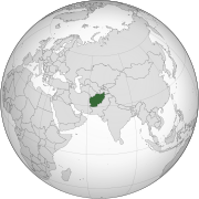
| − | | style="background-color: rgb(219, 229, 241); text-align: center; width: | + | | style="background-color: rgb(219, 229, 241); text-align: center; width: 194px;" | [[File:Afghanistan (orthographic projection).svg|center|180px|Location of Afghanistan|alt=Location _______.png]] |
|- | |- | ||
| − | | colspan="3" style="background-color: rgb(219, 229, 241); width: | + | | colspan="3" style="background-color: rgb(219, 229, 241); width: 177px;" | '''Capital''' |
| − | | style="background-color: rgb(219, 229, 241); width: | + | | style="background-color: rgb(219, 229, 241); width: 194px;" | <span style="line-height: 20.39772605895996px;">Kabul </span><span style="line-height: 20.39772605895996px;">(34° 32′ 0″ N, 69° 10′ 0″ E)</span> |
|- | |- | ||
| − | | colspan="3" style="background-color: rgb(219, 229, 241); width: | + | | colspan="3" style="background-color: rgb(219, 229, 241); width: 177px;" | '''Official Languages(s)''' |
| − | | style="background-color: rgb(219, 229, 241); width: | + | | style="background-color: rgb(219, 229, 241); width: 194px;" | Dari (Persian) and Pashto |
|- | |- | ||
| − | | colspan="3" style="background-color: rgb(219, 229, 241); width: | + | | colspan="3" style="background-color: rgb(219, 229, 241); width: 177px;" | '''Government''' |
| − | | style="background-color: rgb(219, 229, 241); width: | + | | style="background-color: rgb(219, 229, 241); width: 194px;" | Islamic republic |
|- | |- | ||
| − | | colspan="3" style="background-color: rgb(219, 229, 241); width: | + | | colspan="3" style="background-color: rgb(219, 229, 241); width: 177px;" | '''President''' |
| − | | style="background-color: rgb(219, 229, 241); width: | + | | style="background-color: rgb(219, 229, 241); width: 194px;" | Hamid Karzai |
|- | |- | ||
| − | | colspan="3" style="background-color: rgb(219, 229, 241); width: | + | | colspan="3" style="background-color: rgb(219, 229, 241); width: 177px;" | '''Total Area''' |
| − | | style="background-color: rgb(219, 229, 241); width: | + | | style="background-color: rgb(219, 229, 241); width: 194px;" | 647,500 km² |
|- | |- | ||
| − | | colspan="3" style="background-color: rgb(219, 229, 241); width: | + | | colspan="3" style="background-color: rgb(219, 229, 241); width: 177px;" | '''Population''' |
| − | | style="background-color: rgb(219, 229, 241); width: | + | | style="background-color: rgb(219, 229, 241); width: 194px;" | 29.8 million |
|- | |- | ||
| − | | colspan="3" style="background-color: rgb(219, 229, 241); width: | + | | colspan="3" style="background-color: rgb(219, 229, 241); width: 177px;" | '''Rural Population''' |
| − | | style="background-color: rgb(219, 229, 241); width: | + | | style="background-color: rgb(219, 229, 241); width: 194px;" | 23 million (77%) |
|- | |- | ||
| − | | colspan="3" style="background-color: rgb(219, 229, 241); width: | + | | colspan="3" style="background-color: rgb(219, 229, 241); width: 177px;" | '''Urban Population''' |
| − | | style="background-color: rgb(219, 229, 241); width: | + | | style="background-color: rgb(219, 229, 241); width: 194px;" | 6.8 million (23%) |
|- | |- | ||
| − | | colspan="3" style="background-color: rgb(219, 229, 241); width: | + | | colspan="3" style="background-color: rgb(219, 229, 241); width: 177px;" | '''Population Density''' |
| − | | style="background-color: rgb(219, 229, 241); width: | + | | style="background-color: rgb(219, 229, 241); width: 194px;" | 43 Persons per km² |
|- | |- | ||
| − | | colspan="3" style="background-color: rgb(219, 229, 241); width: | + | | colspan="3" style="background-color: rgb(219, 229, 241); width: 177px;" | '''GDP (Nominal)''' |
| − | | style="background-color: rgb(219, 229, 241); width: | + | | style="background-color: rgb(219, 229, 241); width: 194px;" | $15.608 billion |
|- | |- | ||
| − | | colspan="3" style="background-color: rgb(219, 229, 241); width: | + | | colspan="3" style="background-color: rgb(219, 229, 241); width: 177px;" | '''GDP Per Capita''' |
| − | | style="background-color: rgb(219, 229, 241); width: | + | | style="background-color: rgb(219, 229, 241); width: 194px;" | $517 |
|- | |- | ||
| − | | colspan="3" style="background-color: rgb(219, 229, 241); width: | + | | colspan="3" style="background-color: rgb(219, 229, 241); width: 177px;" | '''Currency''' |
| − | | style="background-color: rgb(219, 229, 241); width: | + | | style="background-color: rgb(219, 229, 241); width: 194px;" | Afghani (AFN) |
|- | |- | ||
| − | | colspan="3" style="background-color: rgb(219, 229, 241); width: | + | | colspan="3" style="background-color: rgb(219, 229, 241); width: 177px;" | '''Time Zone''' |
| − | | style="background-color: rgb(219, 229, 241); width: | + | | style="background-color: rgb(219, 229, 241); width: 194px;" | CET (UTC+04:30) |
|- | |- | ||
| − | | colspan="3" style="background-color: rgb(219, 229, 241); width: | + | | colspan="3" style="background-color: rgb(219, 229, 241); width: 177px;" | '''Electricity Generation''' |
| − | | style="background-color: rgb(219, 229, 241); width: | + | | style="background-color: rgb(219, 229, 241); width: 194px;" | <span data-scaytid="5" data-scayt_word="TWh">TWh</span>/year (year) |
|- | |- | ||
| − | | colspan="3" style="background-color: rgb(219, 229, 241); width: | + | | colspan="3" style="background-color: rgb(219, 229, 241); width: 177px;" | '''Calling Code''' |
| − | | style="background-color: rgb(219, 229, 241); width: | + | | style="background-color: rgb(219, 229, 241); width: 194px;" | +93 |
| − | |||
| − | |||
| − | |||
| − | |||
| − | |||
| − | |||
| − | |||
| − | |||
| − | |||
| − | |||
| − | |||
| − | |||
| − | |||
| − | |||
| − | |||
| − | |||
| − | |||
|- | |- | ||
| − | | colspan=" | + | | colspan="3" style="background-color: rgb(219, 229, 241); width: 177px;" | '''Access to Electricity''' |
| + | | style="background-color: rgb(219, 229, 241); width: 194px;" | % | ||
|- | |- | ||
| − | | | + | | colspan="3" style="background-color: rgb(219, 229, 241); width: 177px;" | '''Wind energy (installed capacity)''' |
| − | + | | style="background-color: rgb(219, 229, 241); width: 194px;" | MW (year) | |
|- | |- | ||
| − | | | + | | colspan="3" style="background-color: rgb(219, 229, 241); width: 177px;" | '''Solar Energy (installed capacity)''' |
| − | + | | style="background-color: rgb(219, 229, 241); width: 194px;" | MW (year) | |
| − | + | |} | |
| − | |||
| − | |||
| − | |||
| − | |- | ||
| − | |||
| − | |||
| − | |||
| − | | | ||
| − | |||
| − | |||
| − | |||
| − | |||
| − | |||
| − | |||
| − | |||
| − | |||
| − | |||
| − | |||
| − | |||
| − | |||
| − | |||
| − | |||
| − | |||
| − | |||
| − | | | ||
| − | |||
| − | |||
| − | |||
<br/> | <br/> | ||
| − | |||
| − | |||
| − | |||
| − | |||
| − | |||
| − | |||
| − | |||
| − | |||
| − | |||
| − | |||
| − | |||
| − | |||
| − | |||
| − | |||
| − | |||
| − | |||
| − | |||
| − | |||
| − | |||
| − | |||
| − | |||
| − | |||
| − | |||
| − | |||
| − | |||
| − | |||
| − | |||
| − | |||
| − | |||
| − | |||
| − | |||
| − | |||
| − | |||
| − | |||
| − | |||
| − | |||
| − | |||
| − | |||
| − | |||
| − | |||
| − | |||
| − | |||
| − | |||
| − | |||
| − | |||
| − | |||
| − | |||
| − | |||
| − | |||
| − | |||
| − | |||
| − | |||
| − | |||
| − | |||
| − | |||
| − | |||
| − | |||
| − | |||
| − | |||
| − | |||
| − | |||
| − | |||
| − | |||
| − | |||
| − | |||
| − | |||
| − | |||
| − | |||
| − | |||
| − | |||
| − | |||
| − | |||
| − | |||
| − | |||
| − | |||
| − | |||
| − | |||
| − | |||
| − | |||
<br/> | <br/> | ||
| Line 283: | Line 160: | ||
<references /> | <references /> | ||
| + | [[Category:Country_Energy_Situation]] | ||
[[Category:Afghanistan]] | [[Category:Afghanistan]] | ||
| − | |||
Revision as of 09:45, 3 December 2013
| Afghanistan | |||
|---|---|---|---|
| Capital | Kabul (34° 32′ 0″ N, 69° 10′ 0″ E) | ||
| Official Languages(s) | Dari (Persian) and Pashto | ||
| Government | Islamic republic | ||
| President | Hamid Karzai | ||
| Total Area | 647,500 km² | ||
| Population | 29.8 million | ||
| Rural Population | 23 million (77%) | ||
| Urban Population | 6.8 million (23%) | ||
| Population Density | 43 Persons per km² | ||
| GDP (Nominal) | $15.608 billion | ||
| GDP Per Capita | $517 | ||
| Currency | Afghani (AFN) | ||
| Time Zone | CET (UTC+04:30) | ||
| Electricity Generation | TWh/year (year) | ||
| Calling Code | +93 | ||
| Access to Electricity | % | ||
| Wind energy (installed capacity) | MW (year) | ||
| Solar Energy (installed capacity) | MW (year) | ||
Overview
Geography and Climatic Conditions
- Arid to semiarid; cold winters and hot summers
- Mean temperature (°C min/max): 4.3/19.6 [1]
- Natural gas, petroleum, coal [2]
- Land area covered by forest: 1.3%
- Forest annual rate of change: 0% [3]
Socioeconomical Situation
Income Sources
- Agriculture: 79%
- Industry: 6%
- Services: 16%
National Energy Situation
Energy Supply
Electricity
Sources
- Hydropower 63,7%
- fossil fuels 35,3%
Stability
Energy Consumption
National Level
Electricity
Household Level
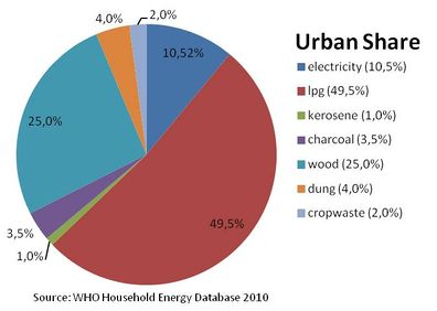
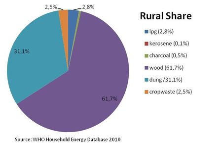
Percentage of energy types used for cooking in rural areas [4]
Percentage of energy types used for cooking in rural areas. [4]
Percentage of Population Using Solid Fuels
National: >95% [5]
Solid Fuel Use Impact on Health
Total annual deaths attributable to solid fuel use: 23900 persons
Percentage of national burden of diseases attributable to solid fuel use: 4.9% [6]
Access Rate
Electrification Rate
Electrification rate in households:[7]
- National: 23%
- Urban: 74%
- Rural: 3%
Policy Framework, Laws and Regulations
Relevant Institutions and Organisations
Existing Projects
Further Information
References
- ↑ UN Data (2008): http://data.un.org/CountryProfile.aspx?crName=Afghanistan
- ↑ CIA - The World Factbook: https://www.cia.gov/library/publications/the-world-factbook/geos/af.html
- ↑ FAO (2011) The State of the World's Forest
- ↑ 4.0 4.1 WHO 2010: WHO Household Energy Database
- ↑ WHO (2006): Fuels for Life
- ↑ WHO (2006): Fuels for Life
- ↑ The National Risk and Vulnerability Assessment 2005, Kabul, Afghanistan. Cited in WHO (2009) The Energy Access Situation in developing Countries


