Concentrating Solar Power (CSP) - Planning
►Concentrating Solar Power (CSP) - Basics and Introduction
Overview
Site Selection
Site selection includes numerous factors, but a top priority is a good solar resource. For site selection, a representative annual solar resource is required to make comparisons with alternative sites and estimate plant output. Because site selection is always based on historical solar resource data and changes in weather patterns from year to year, more years of data are better for determining a representative annual dataset. Defining a typical meteorological year (TMY) dataset is not a trivial exercise.
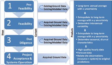
This is a summary of the tools and techniques for evaluating specific CSP sites based on all available information, as well as guidance on steps to improve the on-site determination of the solar resource relevant to the type of CSP technology that is being considered. The overall goal is to help the project developer and investor obtain the best estimates of the solar resource and weather information to address four stages of a CSP project evaluation and operation.
Ideally, a potential CSP site will have several years of high-quality on-site data, using the measurement and metrology procedures, in formats directly relevant to the type of technology being considered. However, in the current CSP market, such data are not usually available, and project developers must rely on a number of techniques to provide the most accurate determination of site resource characteristics based on any available information sources. In the United States, these data sources might include some limited on-site measurements of varying quality, access to nearby measurements that may or may not be precisely applicable to the site because of spatial and temporal variability, access to satellitederived DNI estimates, or access to nearby modeled ground stations.
We assume that during the site-screening and prefeasibility stages, no high-quality on-site data are available, and that annual energy estimates must be derived from historical datasets such as the Perez SUNY satellite data and the NSRDB. During feasibility assessments, including engineering analysis and due diligence, some periods of high-quality measurements are assumed to be available at the site; however, these relative short-term measurements must be extrapolated to long-term records that capture seasonal trends and the interannual variability of solar resources for the site. During the system acceptance and site operation stages, reliance should be on high-quality ground-based measurements, perhaps supplemented to some extent by ongoing satellite-derived measurements for the region. The project developer should consult the following table when evaluating sites through the various stages of project development.
| Evaluation Step |
Question |
Solutions and Insights |
| Site selection |
What proposed site location(s) need to be evaluated? |
|
| Has a single site been chosen? |
If not, is the developer making a choice among two or more sites, or “prospecting” over a wider area? If choosing among multiple sites, the developer will benefit from using maps and graphical techniques to evaluate both the estimated resource and the uncertainty of those resource estimates. See examples below. | |
| Predicted plant output over its project life |
How can short-term datasets that provide projections over the next few years be extended to long-term (30- year) projections so cash flow projections through the life of the project can be made? |
Different locations may have different interannual variability, e.g., locations more subject to a monsoon effect will have higher interannual variability in the summer months. Typically, on-site data cover at most a few years, so we will discuss procedures for extrapolating these datasets to long-term projections using longer term (up to 45 years) modeled DNI data from the NSRDB as well as how to relate the nearest NSRDB stations to site-specific data. |
| Temporal performance and system operating strategies |
How important are seasonal and diurnal patterns for DNI? |
Most CSP projects will produce electricity for the public utility grid. If time-of-day pricing has been implemented for the consumer, an understanding of the diurnal patterns and monthly mean values during those months when time-of-day pricing is in place may be more important than the estimate of the annual average. If the CSP project includes thermal storage, the need to analyze when the system will build up storage versus when the system provides power to the grid during daylight hours also emphasizes the importance of understanding the diurnal patterns. Thermal storage greatly mitigates the effect of system intermittency, but accurate or realistic daily, hourly, or subhourly solar radiation data may still be needed. |
| Are data needed that most closely match actual concurrent utility load data to conduct grid-integration studies and system intermittency? |
In this case, daily, hourly, or even subhourly data may be needed for a specific time period, which cannot be provided by TMY data. | |
| What are the temporal and spatial characteristics of the data sources available to the developer, and how do these characteristics influence the evaluation of system performance? Satellite data usually represent snapshots in time due to the scanning characteristics of the on-board radiometers and are typically considered to range from nearly instantaneous to about 5-minute averages. For SUNY satellite data used in the NSRDB, individual pixel size is 1 km, and the pixel is at the center of the 10-km grid cell. Newer satellite-based methodologies now average the 1-km pixel to 3- or 5-km grid cells |
Example: Measured solar data apply to a specific location, and are usually recorded at short time intervals (6 minutes or less), then averaged to the desired time interval (often hourly). Example: Surface modeled data (e.g., NSRDB/METSTAT) are somewhat smoothed, because they are based on cloud cover observations that can be seen from a point location, typically a circle 40 km in radius, averaged over roughly a 30-minute period. |
Further Information
- Concentrating Solar Power (CSP) Overview.
- For more information on financing of CSP Projects check out the CSP DropBox


