Kyrgyzstan Energy Situation
Capital:
Bishkek
Region:
Coordinates:
42.8667° N, 74.6000° E
Total Area (km²): It includes a country's total area, including areas under inland bodies of water and some coastal waterways.
199,950
Population: It is based on the de facto definition of population, which counts all residents regardless of legal status or citizenship--except for refugees not permanently settled in the country of asylum, who are generally considered part of the population of their country of origin.
6,974,900 (2022)
Rural Population (% of total population): It refers to people living in rural areas as defined by national statistical offices. It is calculated as the difference between total population and urban population.
63 (2022)
GDP (current US$): It is the sum of gross value added by all resident producers in the economy plus any product taxes and minus any subsidies not included in the value of the products. It is calculated without making deductions for depreciation of fabricated assets or for depletion and degradation of natural resources.
11,543,966,559 (2022)
GDP Per Capita (current US$): It is gross domestic product divided by midyear population
1,655.07 (2022)
Access to Electricity (% of population): It is the percentage of population with access to electricity.
99.67 (2021)
Energy Imports Net (% of energy use): It is estimated as energy use less production, both measured in oil equivalents. A negative value indicates that the country is a net exporter. Energy use refers to use of primary energy before transformation to other end-use fuels, which is equal to indigenous production plus imports and stock changes, minus exports and fuels supplied to ships and aircraft engaged in international transport.
49.54 (2014)
Fossil Fuel Energy Consumption (% of total): It comprises coal, oil, petroleum, and natural gas products.
75.48 (2014)
Geography and Climatic Conditions[1]
Kyrgyzstan, also known as the Kyrgyz Republic, is a landlocked country located in the heart of Central Asia. It is bordered by Kazakhstan, Tajikistan, Uzbekistan, and China.
The Tien Shan mountain range cover roughly 95% of the country. Kyrgyzstan has a polar climate in the Tien Shan Mountains, a subtropical climate in the Southwest, and temperate climatic conditions in the Northern foothills. The average low temperature is 4.8°C while the average high temperature is 17.0°C.[2] Shrub land, savannah, and grassland make up 56% of the land and cropland compromises 27%. The land area covered by forest is 4.5% but is decreasing.
Socio-economic Development[3]
Kyrgyzstan's population is 5.57 million and the population density is 27 people per square kilometer. Urban population compromises 35% while the rural population makes up 65%. The literacy rate (age 15+) is 98.7%
The GDP in 2010 was 4.6 billion US$ and the GDP per capital was US$ 860. GDP grew more than 6% in 2007-08, but declined after that. National income sources share consist of 48% agriculture, 12.5% industry, and 39.5% services.
Energy Situation
In contrast to neighboring countries, Kyrgyzstan has small amounts of fossil fuels, but enjoys large amounts of water resources and an abundant supply of hydro power. The bulk (90%) of Kyrgyzstan's generating capacity is hydro power and the country has for some time now considered the development of hydro power resources as the central foundation of its overall economic development.
Kyrgyzstan also has locally exploitable coal, oil, and natural gas.It was the first country in the Commonwealth of Independent States(CIS) to develop an independent regulatory agency for economic regulation of the energy sector. Primary energy shares in 2008 comprised of the following : Hydro 31.8%, coal 18.5%, gas 21.5%, oil 28.1%, renewable and waste 0.1%. [4] Approximately 95% of the population is connected to the grid. Losses in the distribution system range from 40-50% and reliability is poor. Electricity losses are greater in residential areas than non-residential areas and bout 30% of the distribution systems need to be replaced.
Household Energy Situation
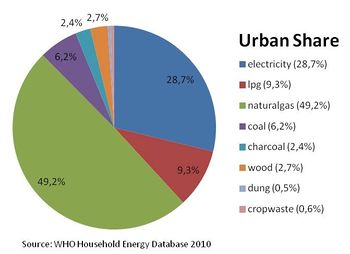
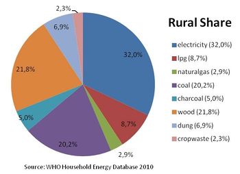
Percentage of energy types used for cooking in urban areas and Rural areas
Solid biomass will become even more popular with the current outages of power, eventual tariff increase, and world pricing trends.The percentage of the population using solid fuels (charcoal, coal, cropwaste, dung and wood) as cooking energy is summarized below:
| National: 37.4% | urban: 12.4% | rural: 56.4% |
Impact of Solid Fuel Use on Health
• Total annual deaths attributable to solid fuel use: 1600 persons
• Percentage of national burden of diseases attributable to solid fuel use: 3.3%
Renewable Energy
Low tariffs and abundant hydroelectric power resources have limited the development of renewable energy sources. Hydro-power is the only documented renewable energy source for electricity production on national level
There are, however, some potentials for solar energy and large scale and micro-hydro power plants. There are about 2,600 hours of sunshine per year and radiation is 1,500-1,900 kW/m² per year. In addition, a law on renewable energy was adopted in 2008. It includes biomass small scale projects, small hydropower programs, solar small scale projects and wind energy in the national program. Finally, some biogas plants have been established, but only by private initiatives.
Further Information
References
- ↑ GIZ (2009): Regional Reports on Renewable Energies Energies - 30 Country Analysis on Potentials and markets
- ↑ http://data.un.org/CountryProfile.aspx?crName=
- ↑ https://www.cia.gov/library/publications/the-world-factbook/geos/kg.html
- ↑ http://www.iea.org/stats


