SPIS Toolbox - Evaluate Geophysical Parameters
2. EVALUATION OF GEOPHYSICAL PARAMETERS
Several geophysical parameters can be used to assess SPIS markets. This module highlights 3 that are crucial to the viability of SPIS applications as discussed in Chapter 1: Land cover-land use, solar irradiation and precipitation (under water availability). If the state of these three parameters is unfavourable in the area under assessment, SPIS is unlikely to be practical. An additional 4 parameters that are key to the market assessment for SPIS are also identified – these do not affect the viability of SPIS; they affect the success of SPIS adoption on a case by case basis. The 7 parameters are expounded on below.
LAND COVER/ LAND USE
Land Cover refers to the physical and biological cover over the surface of the earth including water, bare surfaces, forests, and artificial structures among others. Land use on the other hand refers to how people utilize the land whether for recreation, agriculture or wildlife habitats among others.
Land cover/land use is one of the fundamental parameters to be considered during the identification of potential markets for SPIS as it helps determine feasible locations for agriculture from which other parameters may be considered. Land cover is measured either through direct field observations or through remote sensing techniques involving the analysis of satellite and aerial imagery. Based on the land cover analysis, land use data can be inferred through ancillary data. The data assists decision makers and stakeholders in cross-cutting sectors to understand the dynamics of a changing environment and ensure sustainable development.
Land cover data typically consists of eight classes including wetlands, water bodies, urban, shrubs, grassland, forests, bare land and agricultural land. These may, however, be classified into varying classes depending on the source of data. The FAO framework for land suitability for instance, divides land into four classes ranging from highly suitable land for agriculture (S1) to currently not suitable land (S4). For the 8 classes listed above, ‘agricultural land’ can be classified as highly suitable (S1) and ‘grassland’, which requires land clearing and levelling, as moderately suitable (S2). ‘Shrub land’ and ‘bare land’, which require higher initial investment for land preparation can be classified as marginally suitable (S3) while ‘forest’, ‘water’, ‘urban’, and ‘wetlands’ can be categorized as not suitable (S4).
In assessing market potential for SPIS for a given country or region, stakeholders need to assess the irrigation viability of their target location from a land cover-land use perspective. For example, areas that are mostly classified as S1 land would have higher potential for SPIS compared to those that are highly urbanized or classified as wetlands.
It should be noted that desktop analysis of land cover/land use data through application of remote sensing techniques should be followed by ground truthing to ascertain the land cover/land use in the selected regions prior to investment.
OUTCOME/PRODUCT
- Classification of land based on agricultural suitability
- Selection of optimal sites to promote solar powered irrigation
DATA/REQUIREMENTS
- Land use - land cover data
- Land suitability classification frameworks (e.g. FAO)
PEOPLE/STAKEHOLDERS
- Land Surveyors
- Remote sensing analysts
- Government land ministries
IMPORTANT ISSUES
It is always important to follow up desktop analysis of landcover with actual on-ground visits to the selected areas. Satellite and aerial images are typically very accurate however if one is not using up to date datasets it becomes important to verify the selection.
SOLAR IRRADIATION
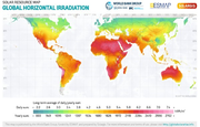
Solar irradiation is a key factor in gauging the market potential of SPIS within a region. It refers to the amount of energy incident per unit area on the earth’s surface in units of watts hours per square meter. PV systems use Global Horizontal Irradiation (GHI) which is the total amount of radiation received from above by a horizontal surface. GHI consists of both Direct Normal Irradiation (DNI) – the amount of solar radiation received per unit area by a surface that is always held perpendicular to the incoming rays and; Diffuse Horizonal Irradiation (DHI) – the amount of radiation received per unit area by a surface that does not arrive on a direct path from the sun, but has been scattered by molecules and particles in the atmosphere.
Solar radiation can be categorized into four classes: levels less than 2.6kWh/m2 are classified as low solar radiation while solar irradiance between 2.6-3kWh/m2 is moderate solar radiation; irradiance of between 3-4kWh/m2 is high solar radiation and irradiance higher than 4kWh/m2 is very high radiation. It is important to note that the classification is used for purposes of distinguishing the efficiency of systems as advances in solar technologies have allowed for the set-up of systems in almost all areas that receive radiation. In areas of low radiation, system efficiency will be compromised due to lower panel output. Additionally, set up of solar panels in regions of low solar radiation could lead to high set up costs resulting from the use of a greater number of panels to generate the same output as regions with higher insolation. It is therefore noted that, because of technological advances, solar irradiation is more of an economic consideration than a question of technical feasibility.
OUTCOME / PRODUCT
- Classification of regions based on GHI or PV system output
- Identification of optimal sites for SPIS
DATA REQUIREMENTS
- Global horizontal irradiation data
PEOPLE / STAKEHOLDERS
- Solar PV system installers
- Meteorological service providers
- Solar equipment suppliers
IMPORTANT ISSUES
- There are various other factors that affect the functionality of a PV system in addition to solar irradiance. Two of the most important include temperature and aspect which are further expounded on in the ambient temperature and topography sections of the module.


