Knowledge fuels change
For over a decade, Energypedia has shared free, reliable energy expertise with the world.
We’re now facing a serious funding gap.
Help keep this platform alive — your donation, big or small, truly matters!
Thank you for your support
Difference between revisions of "Togo Energy Situation"
***** (***** | *****) |
***** (***** | *****) |
||
| Line 24: | Line 24: | ||
The longest river is the Mono with 467 km length. It runs from north to south and can be used as a waterway for 50 km. The river is also used for energy production with a large hydroelectric power plant, at the Nangbeto Dam. The reservoir near Atakampé dams the river Mono. The lake is used for irrigation for agriculture and for electricity production. (Worldbank, 2017) | The longest river is the Mono with 467 km length. It runs from north to south and can be used as a waterway for 50 km. The river is also used for energy production with a large hydroelectric power plant, at the Nangbeto Dam. The reservoir near Atakampé dams the river Mono. The lake is used for irrigation for agriculture and for electricity production. (Worldbank, 2017) | ||
| + | |||
== Climate == | == Climate == | ||
| Line 29: | Line 30: | ||
The climate is tropical humid all year round, with average temperatures of 30°C in the north and 27°C on the coast in the south. There is only a slight cooling at night. Due to the elongated shape of the country, there are different climatic conditions in the north and south of the country. The North is strongly influenced by the continental climate. The rainy season takes place there from May to October. August is the coolest month, January the driest. Located on the coast, the south, is strongly influenced by the maritime climate. There are two rainy seasons from April to June and from September to November. The driest month is December, the coolest month is August. (DWD, 2020) | The climate is tropical humid all year round, with average temperatures of 30°C in the north and 27°C on the coast in the south. There is only a slight cooling at night. Due to the elongated shape of the country, there are different climatic conditions in the north and south of the country. The North is strongly influenced by the continental climate. The rainy season takes place there from May to October. August is the coolest month, January the driest. Located on the coast, the south, is strongly influenced by the maritime climate. There are two rainy seasons from April to June and from September to November. The driest month is December, the coolest month is August. (DWD, 2020) | ||
| + | <br/> | ||
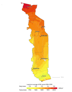
| − | + | [[File:Figure 2 Solar irradiation in Togo.png|thumb|center|250pxpx|Solar irradiation in Togo (Global Solar, 2019)]] | |
| − | [[File:Figure 2 Solar irradiation in Togo.png|thumb|center| | ||
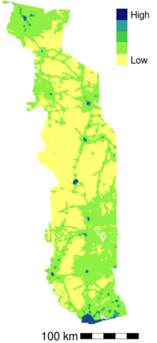
The high and over the year relatively constant solar radiation results in a high value of available solar energy. By means of satellite data of the solar energy per day and per year it can be estimated which region is particularly suitable to produce solar energy. The solar irradiation increases from south to north. In the dry regions in the very north of the country, the solar irradiation reaches its maximum with a value of 2045 kWh/m² per year. (Global Solar, 2019) | The high and over the year relatively constant solar radiation results in a high value of available solar energy. By means of satellite data of the solar energy per day and per year it can be estimated which region is particularly suitable to produce solar energy. The solar irradiation increases from south to north. In the dry regions in the very north of the country, the solar irradiation reaches its maximum with a value of 2045 kWh/m² per year. (Global Solar, 2019) | ||
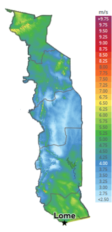
| − | [[File:Figure 3 Wind map of Togo.png|thumb|center| | + | [[File:Figure 3 Wind map of Togo.png|thumb|center|222px|Wind map of Togo (GlobalWind, 2019)]] |
According to the data of the Global Wind Atlas, Togo is located in an area with very low winds. On the coast in the south, wind speeds are on average higher than in the interior. Furthermore, there are greater amounts of wind speeds in higher and mountainous areas. (Global Wind, 2019) | According to the data of the Global Wind Atlas, Togo is located in an area with very low winds. On the coast in the south, wind speeds are on average higher than in the interior. Furthermore, there are greater amounts of wind speeds in higher and mountainous areas. (Global Wind, 2019) | ||
| − | |||
Revision as of 10:17, 28 May 2020
Capital:
Lomé
Region:
Coordinates:
6.7° N, 1.13° E
Total Area (km²): It includes a country's total area, including areas under inland bodies of water and some coastal waterways.
XML error: Mismatched tag at line 6.
Population: It is based on the de facto definition of population, which counts all residents regardless of legal status or citizenship--except for refugees not permanently settled in the country of asylum, who are generally considered part of the population of their country of origin.
XML error: Mismatched tag at line 6. ()
Rural Population (% of total population): It refers to people living in rural areas as defined by national statistical offices. It is calculated as the difference between total population and urban population.
XML error: Mismatched tag at line 6. ()
GDP (current US$): It is the sum of gross value added by all resident producers in the economy plus any product taxes and minus any subsidies not included in the value of the products. It is calculated without making deductions for depreciation of fabricated assets or for depletion and degradation of natural resources.
XML error: Mismatched tag at line 6.2 ()
GDP Per Capita (current US$): It is gross domestic product divided by midyear population
XML error: Mismatched tag at line 6. ()
Access to Electricity (% of population): It is the percentage of population with access to electricity.
XML error: Mismatched tag at line 6.no data
Energy Imports Net (% of energy use): It is estimated as energy use less production, both measured in oil equivalents. A negative value indicates that the country is a net exporter. Energy use refers to use of primary energy before transformation to other end-use fuels, which is equal to indigenous production plus imports and stock changes, minus exports and fuels supplied to ships and aircraft engaged in international transport.
XML error: Mismatched tag at line 6.no data
Fossil Fuel Energy Consumption (% of total): It comprises coal, oil, petroleum, and natural gas products.
XML error: Mismatched tag at line 6.no data
Introduction
Geographie
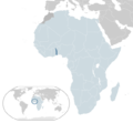
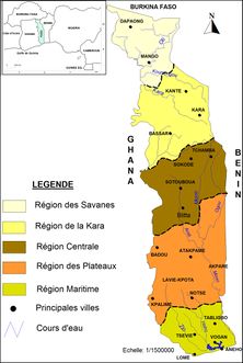
Togo is a state in West Africa, located on the Gulf of Guinea. It borders Burkina Faso to the north, Benin to the east, Ghana to the west and the Atlantic Ocean to the south. The country covers almost 57.000 km². The plains in the north and south are dominated by savannah land, which makes up about 23% of the country's total area. About 16 % of the country is covered by tropical rainforests and savannah forests, about 33 % is used as meadow or grassland and about a quarter is used as agricultural land, especially for coffee, tea, cocoa, cotton, coconut and peanuts, cassava, rice, millet and corn. The country is divided into the regions Maritime, Plateaux, Central, Kara, Savanes. (Togo, 2020)
The longest river is the Mono with 467 km length. It runs from north to south and can be used as a waterway for 50 km. The river is also used for energy production with a large hydroelectric power plant, at the Nangbeto Dam. The reservoir near Atakampé dams the river Mono. The lake is used for irrigation for agriculture and for electricity production. (Worldbank, 2017)
Climate
The climate is tropical humid all year round, with average temperatures of 30°C in the north and 27°C on the coast in the south. There is only a slight cooling at night. Due to the elongated shape of the country, there are different climatic conditions in the north and south of the country. The North is strongly influenced by the continental climate. The rainy season takes place there from May to October. August is the coolest month, January the driest. Located on the coast, the south, is strongly influenced by the maritime climate. There are two rainy seasons from April to June and from September to November. The driest month is December, the coolest month is August. (DWD, 2020)
The high and over the year relatively constant solar radiation results in a high value of available solar energy. By means of satellite data of the solar energy per day and per year it can be estimated which region is particularly suitable to produce solar energy. The solar irradiation increases from south to north. In the dry regions in the very north of the country, the solar irradiation reaches its maximum with a value of 2045 kWh/m² per year. (Global Solar, 2019)
According to the data of the Global Wind Atlas, Togo is located in an area with very low winds. On the coast in the south, wind speeds are on average higher than in the interior. Furthermore, there are greater amounts of wind speeds in higher and mountainous areas. (Global Wind, 2019)
People and Society
Togo is one of the most densely populated countries in Africa, with most of the population living in rural communities, with the highest density in the south near the Atlantic coast. The distribution of the population is very uneven due to variations in soil and terrain. The population is generally concentrated in the south and along the major north-south motorway that connects the coast with the Sahel. The age distribution is also uneven; almost half of the Togolese are less than fifteen years old.
French, the official language, is used in administration and documentation. The public primary schools combine French with "Ewe" or "Kabye" as the language of instruction, depending on the region. English is spoken in neighboring Ghana and taught in Togolese secondary schools. Therefore, many Togolese, especially in the south and along the border to Ghana, speak some English. (CIA World, 2015)
The population of Togo is estimated by the UN at 8 million in 2018. The five largest cities in the country are: Lomé (capital), Sokode, Kara, Atakpame and Kpalime. In total, these cities have a population of 3.3 million and 4.7 million in the countryside. This means that 41.7% of the total population lives in urban areas. There are many different ethnic groups in Togo. It is estimated that there are up to 37 different groups. Among the largest are the Adja-Ewe/Mina with 42.4% and the Kabye/Tem with 25.9%. (2013 - 14 est.) (UN, 2019)
The population of Togo is estimated to have grown four times its size between 1960 and 2010. With almost 60% of the population under the age of 25 and a high annual growth rate, largely due to high fertility, Togo's population is expected to continue to grow in the foreseeable future. In 2008, Togo abolished fees for primary school enrolment, which led to a higher enrolment rate, but increased the pressure on limited classroom space, teachers and materials. Togo is well on the way to establishing universal primary education. However, the quality of education, the low percentage of girls and the low enrolment rate in secondary and higher education remain challenges. (CIA World, 2015)
Energy Situation
Since March 2019, the Government of Togo is offering subsidies to Togolese households to cover the cost of off-grid solar power systems. This subsidy will cover the high upfront cost of the solar systems and aims to increase the adoption of solar home systems. Last year, the UK based BBOXX won a tender to electrify 30,000 Togolese household and another company, Soleva signed a similar agreement with the Togo Government. Under this program, the government will issue monthly vouchers to households operating a BBOXX or Soleva system to finance the system.A total of 100,000 households are expected to have installed a solar kit in 2020 and 550,000 households by 2030. This is part of Togo’s strategy to bring access to electricity to 8 million people by 2030.[1]
Renewable Energy
Fossil Fuels
Key Problems of the Energy Sector
In accordance to Power Africa, these following challenges are the biggest for Togo's energy sector[2]:
- Limited experience with independent power producers (IPPs)
- High technical and commercial losses as a result of non-payments and aging infrastructure
- Lack of an integrated electrification strategy that aligns on- and off-grid access goals
Policy Framework, Laws and Regulations
Institutional Set up in the Energy Sector
Other Key Actors / Activities of Donors, Implementing Agencies, Civil Society Organisations
Further Information
- Togo subsidies off-grid solar to extend electricity access to all
- USAID Power Africa: Togo Factsheet
References
- ↑ https://af.reuters.com/article/topNews/idAFKCN1QJ09L-OZATP
- ↑ Power Africa. (2018). Togo Factsheet. Retrieved from: https://www.usaid.gov/sites/default/files/documents/1860/Togo_-_November_2018_Country_Fact_Sheet.pdf


