Knowledge fuels change
For over a decade, Energypedia has shared free, reliable energy expertise with the world.
We’re now facing a serious funding gap.
Help keep this platform alive — your donation, big or small, truly matters!
Thank you for your support
Difference between revisions of "Togo Energy Situation"
***** (***** | *****) |
***** (***** | *****) |
||
| Line 11: | Line 11: | ||
= Introduction = | = Introduction = | ||
| + | |||
| Line 17: | Line 18: | ||
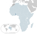
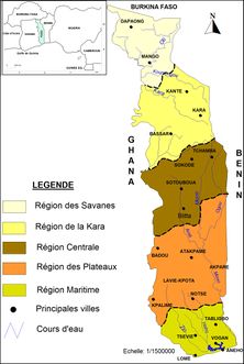
Togo is a state in West Africa, located on the Gulf of Guinea. It borders Burkina Faso to the north, Benin to the east, Ghana to the west and the Atlantic Ocean to the south. The country covers almost 57.000 km². The plains in the north and south are dominated by savannah land, which makes up about 23% of the country's total area. About 16 % of the country is covered by tropical rainforests and savannah forests, about 33 % is used as meadow or grassland and about a quarter is used as agricultural land, especially for coffee, tea, cocoa, cotton, coconut and peanuts, cassava, rice, millet and corn. The country is divided into the regions Maritime, Plateaux, Central, Kara, Savanes. (Togo, 2020) | Togo is a state in West Africa, located on the Gulf of Guinea. It borders Burkina Faso to the north, Benin to the east, Ghana to the west and the Atlantic Ocean to the south. The country covers almost 57.000 km². The plains in the north and south are dominated by savannah land, which makes up about 23% of the country's total area. About 16 % of the country is covered by tropical rainforests and savannah forests, about 33 % is used as meadow or grassland and about a quarter is used as agricultural land, especially for coffee, tea, cocoa, cotton, coconut and peanuts, cassava, rice, millet and corn. The country is divided into the regions Maritime, Plateaux, Central, Kara, Savanes. (Togo, 2020) | ||
| + | <br/> | ||
| − | + | [[File:Figure1 Togo Map.jpg|thumb|center|222pxpx|Togo: Country and Region|alt=Togo: Country and Region]] | |
| − | [[File:Figure1 Togo Map.jpg| | ||
Revision as of 10:10, 28 May 2020
Capital:
Lomé
Region:
Coordinates:
6.7° N, 1.13° E
Total Area (km²): It includes a country's total area, including areas under inland bodies of water and some coastal waterways.
XML error: Mismatched tag at line 6.
Population: It is based on the de facto definition of population, which counts all residents regardless of legal status or citizenship--except for refugees not permanently settled in the country of asylum, who are generally considered part of the population of their country of origin.
XML error: Mismatched tag at line 6. ()
Rural Population (% of total population): It refers to people living in rural areas as defined by national statistical offices. It is calculated as the difference between total population and urban population.
XML error: Mismatched tag at line 6. ()
GDP (current US$): It is the sum of gross value added by all resident producers in the economy plus any product taxes and minus any subsidies not included in the value of the products. It is calculated without making deductions for depreciation of fabricated assets or for depletion and degradation of natural resources.
XML error: Mismatched tag at line 6.2 ()
GDP Per Capita (current US$): It is gross domestic product divided by midyear population
XML error: Mismatched tag at line 6. ()
Access to Electricity (% of population): It is the percentage of population with access to electricity.
XML error: Mismatched tag at line 6.no data
Energy Imports Net (% of energy use): It is estimated as energy use less production, both measured in oil equivalents. A negative value indicates that the country is a net exporter. Energy use refers to use of primary energy before transformation to other end-use fuels, which is equal to indigenous production plus imports and stock changes, minus exports and fuels supplied to ships and aircraft engaged in international transport.
XML error: Mismatched tag at line 6.no data
Fossil Fuel Energy Consumption (% of total): It comprises coal, oil, petroleum, and natural gas products.
XML error: Mismatched tag at line 6.no data
Introduction
Geographie
Togo is a state in West Africa, located on the Gulf of Guinea. It borders Burkina Faso to the north, Benin to the east, Ghana to the west and the Atlantic Ocean to the south. The country covers almost 57.000 km². The plains in the north and south are dominated by savannah land, which makes up about 23% of the country's total area. About 16 % of the country is covered by tropical rainforests and savannah forests, about 33 % is used as meadow or grassland and about a quarter is used as agricultural land, especially for coffee, tea, cocoa, cotton, coconut and peanuts, cassava, rice, millet and corn. The country is divided into the regions Maritime, Plateaux, Central, Kara, Savanes. (Togo, 2020)
Energy Situation
Since March 2019, the Government of Togo is offering subsidies to Togolese households to cover the cost of off-grid solar power systems. This subsidy will cover the high upfront cost of the solar systems and aims to increase the adoption of solar home systems. Last year, the UK based BBOXX won a tender to electrify 30,000 Togolese household and another company, Soleva signed a similar agreement with the Togo Government. Under this program, the government will issue monthly vouchers to households operating a BBOXX or Soleva system to finance the system.A total of 100,000 households are expected to have installed a solar kit in 2020 and 550,000 households by 2030. This is part of Togo’s strategy to bring access to electricity to 8 million people by 2030.[1]
Renewable Energy
Fossil Fuels
Key Problems of the Energy Sector
In accordance to Power Africa, these following challenges are the biggest for Togo's energy sector[2]:
- Limited experience with independent power producers (IPPs)
- High technical and commercial losses as a result of non-payments and aging infrastructure
- Lack of an integrated electrification strategy that aligns on- and off-grid access goals
Policy Framework, Laws and Regulations
Institutional Set up in the Energy Sector
Other Key Actors / Activities of Donors, Implementing Agencies, Civil Society Organisations
Further Information
- Togo subsidies off-grid solar to extend electricity access to all
- USAID Power Africa: Togo Factsheet
References
- ↑ https://af.reuters.com/article/topNews/idAFKCN1QJ09L-OZATP
- ↑ Power Africa. (2018). Togo Factsheet. Retrieved from: https://www.usaid.gov/sites/default/files/documents/1860/Togo_-_November_2018_Country_Fact_Sheet.pdf


