SPIS Toolbox - Understanding Groundwater
UNDERSTANDING GROUNDWATER
Groundwater within the hydrogeological cycle
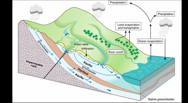
SPIS is based on the abstraction of groundwater from open wells or tube wells. Therefore, it is necessary to understand groundwater systems to manage groundwater in a sustainable manner. Groundwater is the water found underground in the cracks and pores in soil, sand and rock, called aquifer. Aquifers store high amounts of groundwater and are therefore an important reservoir and buffer within the hydrologic cycle (see figure).
Groundwater is naturally recharged by precipitation or by infiltration from rivers and lakes. The underground water movement from areas of recharge to areas of aquifer discharge through springs and seepage to rivers, lakes, wetlands and coastal zones is called groundwater flow. The natural flow of groundwater occurs, generally at low velocities, through pore spaces and fractures in rock materials. Depending on the aquifer geological composition, water flow velocity varies from 1 meter per day to 1 meter per year or per decade. In contrast, velocities of river flow are much faster and expressed in meter per second. Groundwater levels may vary seasonally and annually. They are then high after the wet season and low at the end of the dry season.
Groundwater balance
Under natural conditions, groundwater storage within the aquifer is in balance. It recharges in wet seasons and provides water for the base flow of rivers, lakes and wetland throughout the year. This balance can be disturbed by human interventions that may affect both the amounts of recharge and discharge.
Important agricultural activities with effects on the groundwater balance
| Recharge |
| Agricultural activity |
Process |
Examples for regulative measures |
| Land use |
Soil sealing accelerates surface runoff on the cost of infiltration of rain- and surface water, whereas increased vegetation cover retards runoff and favors infiltration. |
Land use planning that procures local rainwater infiltration. |
| Crop choice |
As crops have different effects on soil moisture and surface runoff, crop choice influences the amount of rainwater infiltration and thereby the recharge, especially of shallow groundwater. |
Prescribed cropping arrangements and planting patterns. |
| Soil compaction |
Due to natural conditions of drying and wetting, heavy machineries and inappropriate tillage top- and subsoil is compacted and groundwater recharge decreases. |
Prescribed cropping arrangements and planting patterns. |
| Soil compaction |
Due to natural conditions of drying and wetting, heavy machineries and inappropriate tillage top- and subsoil is compacted and groundwater recharge decreases. |
Regulations for tillage practices and machinery use. |
| Excess irrigation |
Irrigation itself can be an important factor, as surplus irrigation water may infiltrate and recharge groundwater. |
Sound irrigation scheduling and appropriate techniques. |
| Discharge |
| Groundwater abstraction | Groundwater pumping from wells lowers the water table. | Groundwater abstraction quotas, licensing of drilled wells. |
In order to maintain balanced and plannable groundwater conditions, sustainable groundwater management should be based on the basin's recharge capacity. This capacity is called sustainable yield (or safe yield) of a groundwater system and means the amount that can be extracted without harming ecosystems and communities that depend on it. To determine the sustainable yield it is important to quantify the groundwater recharge.
As recharge processes are complex and dependent of numerous hydrogeological processes, the responsible water authorities and managers need to have as-accurate-as-possible data on the following aspects:
- Total extraction of groundwater by human activities (groundwater pumping) and natural springs
- Whenever possible, the estimation of discharge should rely on metered pumping records and measured spring discharge
- To estimate the recharge, high-resolution data on precipitation, evapotranspiration and runoff are needed. In addition, hydrogeological data on the groundwater flow and underground storage characteristics (e.g. derived from pumping tests) have to be taken into account.
- Land-use and vegetation/crop mapping of the groundwater basin helps to quantify more exactly the evapotranspiration and runoff variables.
- Depending on the available data and resources, the recharge can be estimated via standard formulas and expert knowledge, but also by more sophisticated hydrological (computer) models
In some instances, groundwater may also be subject to artificial recharge, which means the planned technical infiltration of water to groundwater bodies. Some progressive communities are presently practicing the artificial recharge of their aquifers in order to conserve the groundwater resource. For example, in the Terai region of North Bengal (India), gully plugs and bunds have been constructed by local farmer committees to retain rainwater and increase groundwater recharge. This stabilized the water tables and reduced the impact of drought periods on rain-fed paddy cultivation. As a result, the cropping intensity could be doubled and yields as well as farmers’ income improved[1].
Groundwater overexploitation
If the extraction of groundwater is higher than the long-term recharge, groundwater decline regionally. This process is called groundwater over-exploitation. In practice however, over-exploitation is invariably much more concerned with the consequences of intensive groundwater abstraction than about its absolute level. Thus the most appropriate definition for over-exploitation is probably that it is reached when the overall costs of the negative impacts of groundwater exploitation exceed the net benefits of groundwater use, although these impacts are not always easy to predict and/or to quantify in monetary terms. It is also important to stress that some of these negative impacts can arise well before the groundwater abstraction rate exceeds long-term average recharge.
|
Important: Excessive pumping can lead to groundwater depletion. This means that groundwater is extracted at a rate faster than it can be replenished. Aquifer depletion can lead to loss of ecosystems and wetlands, increased greenhouse gas emissions, land subsidence and social conflicts with other water users. |
Pumping groundwater causes a drop of the water table. The water table is the surface of the area saturated with groundwater. When groundwater is pumped, the water table
[1] Tuinhof et al. 2012.Profit from storage. The cost and benefits of water buffering. Wageningen: 3R Water Secretariat.


