Knowledge fuels change - Support energypedia!
For over 10 years, energypedia has been connecting energy experts around the world — helping them share knowledge, learn from each other, and accelerate the global energy transition.
Today, we ask for your support to keep this platform free and accessible to all.
Even a small contribution makes a big difference! If just 10–20% of our 60,000+ monthly visitors donated the equivalent of a cup of coffee — €5 — Energypedia would be fully funded for a whole year.
Is the knowledge you’ve gained through Energypedia this year worth €5 or more?
Your donation keeps the platform running, helps us create new knowledge products, and contributes directly to achieving SDG 7.
Thank you for your support, your donation, big or small, truly matters!
File:FusionMaps-canadawind-jan12.png

Original file (978 × 830 pixels, file size: 113 KB, MIME type: image/png)
Summary
| Description |
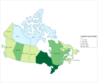
English: Installed wind power capacity by Canadian province as of January 2012. Data collected from www.canwea.ca. Français : La capacité installée d'énergie éolienne par province canadienne de Janvier 2012. Les données recueillies auprès www.canwea.ca. |
| Date | |
| Source | Own work |
| Author | Matthew Welke |
Licensing
- You are free:
- to share – to copy, distribute and transmit the work
- to remix – to adapt the work
- Under the following conditions:
- attribution – You must give appropriate credit, provide a link to the license, and indicate if changes were made. You may do so in any reasonable manner, but not in any way that suggests the licensor endorses you or your use.
- share alike – If you remix, transform, or build upon the material, you must distribute your contributions under the same or compatible license as the original.
File history
Click on a date/time to view the file as it appeared at that time.
| Date/Time | Thumbnail | Dimensions | User | Comment | |
|---|---|---|---|---|---|
| current | 09:30, 10 January 2012 | | 978 × 830 (113 KB) | Matt0401 | Fixed incorrect data and changed scale and ranges to make the image more user friendly. |
File usage
The following page uses this file:


