Click here to register!
File:Orographic map of ashegoda.jpg
From energypedia
No higher resolution available.
Orographic_map_of_ashegoda.jpg (456 × 304 pixels, file size: 227 KB, MIME type: image/jpeg)
Summary
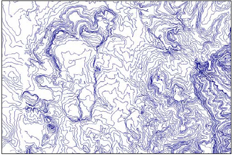
Image shows a height contour map of the Ashegoda wind park site in Ethiopia generated by the SRTM-Shuttle Radar Topography Mission data base. The picture was used for the feasibility study for the Ashegoda wind park.Source: GTZ (2006) Feasibility Study for Wind Park Development in Ethiopia and Capacity Building - Ashegoda Wind Park Site), retrieved 11.7.2011 [[1]]
Licensing
| File from GIZ Source. | This file has been produced specifically for GIZ, but someone other than the author has uploaded the file. Therefore the copyright provisions of the original source apply to this file. In case that the original source and its copyright provisions are unclear, this file can be only used on energypedia within the context of the German Copyright Law. Please report copyright infringements to the energypedia staff so that it can delete the appropriate files. |
|---|
File history
Click on a date/time to view the file as it appeared at that time.
| Date/Time | Thumbnail | Dimensions | User | Comment | |
|---|---|---|---|---|---|
| current | 12:03, 17 July 2011 | | 456 × 304 (227 KB) | ***** (***** | *****) | Image shows a height contour map of the Ashegoda wind park site in Ethiopia generated by the SRTM-Shuttle Radar Topography Mission data base. The picture was used for the feasibility study for the Ashegoda wind park. Category:Ethiopia [[Category:Wind] |
You cannot overwrite this file.
File usage
The following page uses this file:


