SPIS Toolbox - Identify a Potential Market

| ►Back to the Start Page | ►Back to the Module Page | ►Go to the Next Chapter |
1. Identify a Potential Market
Identifying Target Markets
Identifying a market of interest is a pre-cursor to assessing the market’s potential for SPIS. Key to the identification process, and which affects the evaluation of the market, is WHO is interested in the promotion and adoption of SPIS, and WHY they are interested. For instance, a private SPIS company may be looking to break into new markets, developing agencies may want to advance sustainable development goals (SDGs) within a region, and policy makers and government agencies may be interested in growing or diversifying their country’s economy. The parameters presented in this module and their associated weights, may therefore be seen as parameters for both market assessment and gap analysis.
Identification of target markets for SPIS involves the evaluation of numerous parameters. These may include various geo-physical and business environment parameters. For stakeholders who do not have a set target market in mind or who merely want a high-level overview of potential areas where systems could be set up or utilized, this could prove to be a daunting and time-consuming task.
As the guidelines provided in Chapters 2 and 3 help to determine whether a pre-identified location has potential for SPIS rather than identify a target market, this chapter aims to ease the identification process by providing some key considerations in market identification.
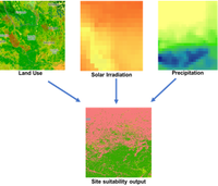
Three geophysical parameters are considered core to the viability of SPIS within an area: solar irradiation, precipitation and land cover/land use. These parameters are highlighted below and elaborated on in the geophysical parameter section of the module.
- Solar irradiation refers to the energy incident per unit area on the earth’s surface measured in Kilowatt hour per square meter (kWh/m2). While advancements in solar PV technologies have enabled tapping into low levels of irradiation, it is generally concluded that the lower the irradiation levels, the less the economic viability of SPIS due to prohibitive capital costs.
- Precipitation is considered a core factor based on the premise that areas receiving rainfall above a certain rain threshold do not require irrigation. For instance, sugarcane is seen to have the highest seasonal water requirement of 1500-2500mm translating to an estimated average water requirement of 200mm per month according to the FAO. It may therefore be said that, areas receiving higher rainfall volumes than 200mm per month have limited application viability for SPIS.
- Land cover/land use allows for the elimination of unsuitable areas including but not limited to forests, urban settlements and snow-covered areas.
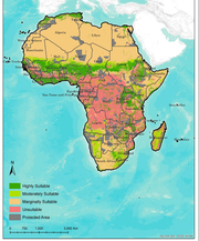
Suitability maps provide a high-level overview of countries or regions that have large land areas that are suitable for solar powered irrigation. This can act as a guide for stakeholders to conduct further evaluation on geophysical parameters and business parameters within the identified countries.
Outcome/Product
- Target market for SPIS
Data Requirements
- Precipitation data
- Land cover land use data
- Solar irradiation data
People/Stakeholders
- Private SPIS companies
- Policy-makers
- Financial institutions
- Development practitioners
- National and local governments
Important Issues
- The guidelines provided in the follow up chapters help to determine whether a pre-identified location has potential for SPIS, rather than identify a target market.
- The Suitability Maps tool provides high levels analysis by layering solar irradiation data, precipitation and land cover-land use.
| ►Back to the Start Page | ►Back to the Module Page | ►Go to the Next Chapter |


